
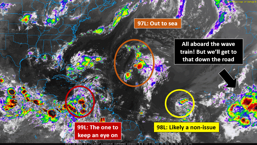
Wednesday, August 25th, 2021 - With Fred, Grace, and Henri out of the way, the Atlantic has given us 3 new Invests as a reminder that the season's peak is upon us. The first two, 97L and 98L, are well off to the east and appear to pose no threat to land. So naturally (and appropriately), our focus turns to the third: 99L in the Caribbean Sea. Though the environment isn't the most favorable for development now, that should change as the wave approaches the NW Caribbean on a possible excursion to the Gulf of Mexico.
With that in mind, and given Grace's rapid intensification into a Category 3 hurricane last week, the weather model websites have gotten their fair share of traffic. I was leading a tropics discussion with fellow FSU students yesterday when the 12Z ECMWF run came in. Sure enough, as soon as I say "watch to see if the ridge weakens on this run!", there's the simulated storm in Louisiana, farther east than any prior runs. Over the next day or so, you'll see a lot of folks say things like "it's tough for a model to be accurate when the center hasn't formed yet!" or "don't focus on one deterministic run!", and so on. Let's use this article to talk about why this is sound advice, and how you can look deeper into the model data besides where a storm goes and how strong it gets.
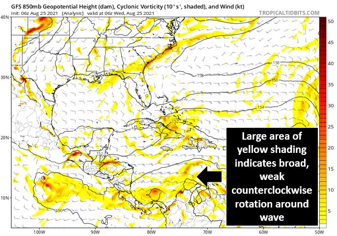
Why It's Tough to Forecast a Storm That Hasn't Formed Yet - Because so much of what causes a tropical cyclone to form happens on small scales that are difficult to capture! Within a wave like 99L, there's a fairly broad area of vorticity (counterclockwise spin) and moisture. To be able to close off a circulation and intensify, this needs to become more concentrated, a process that's handled by the organization of convection (thunderstorms). One prominent theory out there for this is the "vortical hot tower" route: individual convective bursts produce strong vorticity on small scales. If these happen consistently over the same area, they can produce one dominant circulation within the larger wave, which can then intensify. Think of the classic figure skater analogy! When their arms are outstretched over a wide radius, they spin more slowly. But when they move inward, they spin more quickly. While operational forecast models have substantially improved over time, localized convection is still tough to resolve and forecast! The dominant location of spin can bounce around quite a bit in this "genesis" stage, which will produce significant uncertainty in track, land interaction, intensity... you name it.
Why Deterministic (Individual) Runs Should Be Treated With Caution - We don't even know that all of the initial conditions are accurate, and errors grow with time! If we had weather observing sites on every inch of the globe, and had the computing power to model every inch, then this wouldn't be an issue. But especially in the tropics, where the observational network is poor relative to middle latitudes, this is not the case. Numerical weather prediction has come such a long way over the past couple of decades with our advances in both computing capability and theoretical knowledge. But the observations we collect get fed into these models as the starting point, so those gaps will always be present to an extent. Expect to see these deterministic runs (GFS, ECMWF, UKMET, etc.) jump around quite a bit over the next couple of days, in terms of both intensity and track. Ensembles are a nice way to visualize uncertainty - by re-running a model 20 or 30 times with tweaks to the initial conditions, you can see a range of different outcomes. But these will shift too! That's because we're not only focused on the details of the storm itself. To deliver an accurate forecast, we also need to know quite a bit about the environment around it...
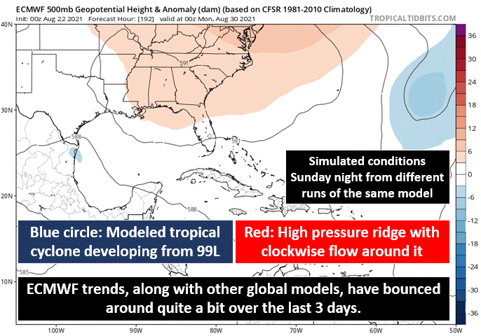
What To Look For Away From the Storm - Obviously, the warm waters of the Gulf of Mexico are something in favor of intensifying 99L, should it get there. And the last couple of storms in the Caribbean (Fred/Grace) didn't do much to cool that down. But there's a lot more to the forecast than the SST! To a first-order, tropical cyclones are steered by the winds in the surrounding environment. This is why all of our Cabo Verde-type storms (emerging from Africa) move from east to west - the easterly trade winds in the tropics carry storms that way. In 99L's case, to determine the direction it will travel, it's useful to look for surrounding large-scale features, and how they are depicted from run to run/as observations come in. Yesterday's shift in model guidance had to do with a ridge of high pressure over the southeastern US, shown below. Prior runs had this as a rather strong feature, with robust clockwise flow around it that would force 99L toward Texas or Mexico. The aforementioned 12Z ECMWF run weakened that ridge significantly, allowing it to be steered further north.


These large-scale patterns aren't usually the first thing our eyes are drawn to when new model runs come in. But they are arguably the most important reason why things change so fluidly! Other examples may include the timing of a trough over the US, which can impart wind shear on a storm and "pick it up" towards an eventual northeast turn out to sea. In addition, upper-level systems like the current low over the Bahamas can introduce wind shear. How these are depicted goes a long way in determining the modeled future of a tropical cyclone. This is why NOAA's upper-level aircraft reconnaissance missions (sample below), as well as the weather balloons launched by NWS offices, are so critical! They don't catch our eye like the low-level recon that flies into the centers of hurricanes, but the data these bring to us helps to more accurately model these large-scale features, which thus greatly enhances forecast confidence.

Another bonus interaction in 99L's case actually stems from the East Pacific - Invest 95E looks set to become a tropical cyclone soon. How quickly this storm develops can actually influence 99L, because a strong East Pacific storm can generate strong outflow, which can harm 99L as wind shear. Shoutout to Eric Webb for pointing that out this morning (@webberweather on Twitter, but like others I've mentioned in my articles, there's a good shot you already follow him if you follow me). Weather happens on all scales! What's happening 1,000 miles ahead of a storm can have just as much relevance as the small-scale convection working to spin it up in the first place. It's important to keep this in mind if you're looking to forecast a tropical cyclone - "think outside the eye", so to speak, and look at these environmental factors to explain WHY things have changed from one model cycle to the next.
That's all for now! The short answer: Yes, 99L has a high ceiling. But there are a lot of things we need to sort out first, which takes time, data, and some work from 99L to put itself together a bit more. For now, if you're along the central or western Gulf coast, tune into the forecast each day as things evolve and confidence improves. With things having picked up over the last 2 weeks, expect more frequent posts for the next month or so, including a little more focus on the current tropics. But if you have anything you'd like to see or learn about, let me know! I hope this puts things into perspective a bit, but if you have any follow-up questions or comments, drop them here, find me on Twitter @JakeCarstens, or reach out any of the other ways on the "About" page of my website. Thanks for reading, and here's hoping things aren't too noisy a week from now!