
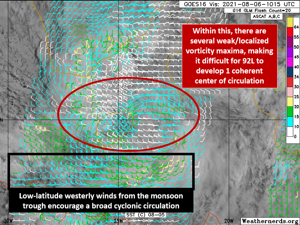
We're now into August, and with that, attention turns to the "wave train" off of Africa for our next series of tropical development candidates. The setup in the Atlantic is interesting, with recently-designated Invest 92L emerging over water near the so-called "monsoon trough", a broad region of convergence and vorticity (spin) in the eastern Atlantic. In the West Pacific, this type of environment is a frequent precursor to tropical cyclone formation. In the case of 92L (seen in the below GIF from weathernerds.org), it's leading to a complex interaction of localized maxima in vorticity, making it tricky for this broad area of convection and rotation to consolidate into one well-defined system.
My most recent article introduced the concept of velocity potential, how to interpret the plots that show it, and its uses for subseasonal hurricane forecasting. I'd encourage you to check it out first if that's something you aren't familiar with! Toward the end, I referenced a couple of different phenomena that contribute heavily to it, and have been cited as reasons (along with climatology) for the expected increase in Atlantic activity over the next few weeks. It's only natural to dive into one of these here: the Madden-Julian Oscillation (MJO), widely considered a critical player in both "intraseasonal" (within the season) variability of tropical cyclone activity, as well as overall tropical rainfall. Rather than take a nosedive into the theory behind the MJO (which is very much still an open book, especially in the convection modeling community!), I'll stick to the basics and consequences, along with breaking down the various plots you'll see online/on social media.
The MJO, named for its initial discovery by Dr. Roland Madden and Dr. Paul Julian 50 years ago, is a large-scale, eastward-moving disturbance in the tropics that generally propagates around the world on a time scale of 30-60 days. Its rainfall signal is generally most pronounced in the Indian Ocean and Western Pacific, but its impacts often extend all the way into the Atlantic and over Africa. As shown in the schematic below from NOAA (climate.gov), an active MJO (its strength can vary quite a bit!) consists of distinct cells of rising and sinking motion. Tying it back to the velocity potential discussion from last week, the region labeled "upward motion" in this schematic would correspond to diverging upper-level winds (negative velocity potential), which can be seen via the green arrows here. The opposite applies for the downward motion cell - upper-level convergence, and a large-scale environment that would suppress convection, inhibiting tropical cyclone development.

Indeed, this is what the Atlantic saw in July: As an MJO event gradually propagated through the Pacific, this cell of downward motion was stationed over the Main Development Region (MDR) in the eastern Atlantic, leading to 4 weeks without tropical cyclones, and even days where any thunderstorm activity was scarce. This is beginning to change, with the main cell of rising motion and upper-level divergence now stationed over the East Pacific, where several named storms have formed over the past week or two. As this moves through the Atlantic, more widespread convection should take place over the tropics, providing more moisture to future waves that emerge from Africa. Every setup has its quirks, but we often look for the threat of strong Cabo Verde-type hurricanes (named because of their formation near the Cabo Verde islands in the eastern Atlantic) to maximize on the back side of one of these rising cells. In this setup, strong rising motion over Africa contributes to vigorous tropical waves, the environment over the Atlantic remains favorable for convection, wind shear is reduced, and the aforementioned moisture left behind by prior waves can help to shield developing disturbances against dry air intrusions.
So let's break down the different plots associated with the MJO! One of the most powerful tools we have is based on an advanced statistical technique called "empirical orthogonal function" (EOF) analysis, performed by Wheeler and Hendon (2004). After taking steps to remove effects from other atmospheric oscillations, such as ENSO and the seasonal cycle, they are able to break down the MJO into 8 phases based on the variability in 2 simple quantities: Zonal (east-west) wind in the lower and upper atmosphere (850 and 200 mb, respectively), and outgoing longwave radiation (OLR). The latter is a proxy for the extent of cloud coverage and rainfall, since clouds trap the "longwave" radiation emitted by the Earth's surface and atmosphere, and reduce the amount of this radiation that escapes to space. Therefore, lower OLR corresponds to more clouds and convection, and vice versa. Tracking the variability in zonal winds gives a picture of the convergence and divergence that takes place at these two vertical levels, which is directly related to the vertical motion and cloud coverage in between.

Starting with the plot above and to the left from the NOAA Climate Prediction Center, the progression of the MJO over the last 40 days is shown in a "phase space" diagram. The numbers on the interior of the plot represent the date, with the color of the line matching with the color of the nearby text indicating the month. For example, the red portion of the line represents the MJO's progress through July. The numbers toward the outside of the plot represent the phase, with the location (i.e. Western Pacific) denoting where the strongest rising motion is taking place. There are some different definitions for the phases out there, but in general, we look to Phases 1 and 2 for upticks in Atlantic activity, when the MJO passes through the basin and over Africa. The axes on the plot essentially refer to the strength of the anomalies in OLR and zonal winds, so a point on the graph that is farther from the center generally corresponds to a more active MJO event. Anything inside the circle, based on the definition from Wheeler and Hendon (2004), is considered to be a weak event.
Moving to the right-hand side, with these simple indices for tracking the MJO, we can perform forecasts of its future phase! That's what the green and yellow lines depict in this plot: different ensemble member forecasts from the GFS for the MJO phase over the next 2 weeks. Most members take the MJO into Phases 1 and 2, consistent with its current position over the Eastern Pacific and its typical eastward track. With this in mind, the expectation is that things should start to especially ramp up in the second half of the month, aligning with peak climatology. Of course, there are always other factors that can get in the way, and as I said a little while earlier, every setup has its own unique quirks. But this is one reason why the updated seasonal forecasts earlier this week maintained their belief of an active season, despite the relative peace and quiet of the last 4 weeks.

I'll wrap up with another useful visual tool in MJO diagnosis and forecasting: the Hovmoller diagram. This is a longitude-time plot that, in this case, depicts the eastward motion of various disturbances like the MJO. In the annotated figure above, you can see the evolution of the MJO throughout 2021 in the form of eastward-propagating anomalies (departures from the mean) of velocity potential at 200 mb. Just like we saw with the phase diagrams before, this type of plot can also be used in forecasting to visualize both the location and strength of the different vertical motion cells associated with the MJO. And this has the particular usefulness of being able to portray the evolution over a long time period. While there are challenges in forecasting the MJO, especially at long range, this can provide some useful insight for subseasonal tropical cyclone prediction.
If you made it this far, thanks for reading! I believe this is my longest article yet, but it's an important topic to dive into for our purposes, as well as a fascinating subject of ongoing research. In fact, the American Meteorological Society's Annual Meeting has an entire symposium devoted each year to the MJO, and its importance for subseasonal forecasting. Beyond tropical cyclones, the MJO is an important factor in tropical rainfall extremes, and has even been shown to have some relevance to mid-latitude weather. So if this is something that interests you, I encourage you to dive into the wealth of content out there! In any case, I hope this was a good introduction to what the MJO is, and the different ways we can detect, forecast, and visualize it. If you have any follow-up questions/comments, feel free to drop me a comment here, follow me on Twitter @JakeCarstens, or contact me at any of the other platforms on the "About" page of this website. Here's hoping the next time I write, we won't quite be on to Tropical Storm Fred yet!